Unmanned aerial vehicles (UAVs), sometimes referred to as drones, are being utilized more and more in various industries to safely and efficiently inspect critical assets and infrastructure that would otherwise be difficult to access. UAV aircraft have no pilot on board; they are controlled remotely by a pilot at a ground-based control station or flown autonomously with a preprogrammed flight plan. Unlike their military counterparts that are used for reconnaissance and high-risk combat missions, commercial UAVs are designed specifically for civil applications, such as the inspection of oil and gas assets (offshore oil and gas platforms, drillings rigs, and pipelines), transportation infrastructure (bridges, roads, railways, and tunnels), and energy systems (power lines, wind farms, and solar parks) (Figure 1).
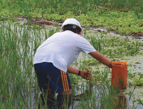
According to NACE International member Jorge J. Cantó, executive director of Corrosión y Protección (Cuernavaca, Morelos, Mexico), UAVs can be equipped with multiple technologies, such as cameras and state-of-the-art sensors, to gather a variety of data on the structures being inspected. Currently, Corrosión y Protección is using UAVs to conduct visual surveys and collect cathodic protection (CP) data from rectifiers and test stations along inaccessible oil and gas pipelines. “We are using these in very remote locations—areas where driving in a truck or walking is not possible or feasible for several reasons,” says Cantó. He notes that Latin America has vast areas of swamps, jungles, and other places where it is preferable to collect CP data remotely rather than repeatedly send in personnel. The UAVs can fly over the pipelines and collect CP readings on a regular basis, and essentially replace “walking the pipeline” every month or quarter (Figure 2). This ensures that readings are taken regardless of the season, time of day, accessibility of the pipeline, or any other obstacle that could be encountered.

“For many countries and many areas, this technology is the only way to be able to actually get these readings in an economically feasible way,” Cantó comments. “They are the vital signs of the pipeline. If you miss a check-up one year and the next year, and then the next year, you are literally operating blind,” he emphasizes. Cantó adds that the biggest onshore oil reserves in Mexico are in areas that are difficult to access. In those areas, he says, this type of technology is really helping to regularly collect pipeline CP data.
Transmitting and Collecting Data
According to Cantó, wireless CP data collection is a proven technique that has been done for years with test stations. Data are transmitted using satellite or cellular signals and technicians collect data as they drive by the test stations in their vehicles. Collecting data from the air, he comments, is a breakthrough for ensuring pipeline integrity in remote locations. For a UAV to be able to collect the readings, the pipeline’s CP test stations and rectifiers must be instrumented with equipment intended to collect, store, and then send data to the UAV when it passes by. Because many remote areas do not have cellular network service, a radio frequency transmitter for commercial application is used to send data to the UAV.
To conduct potential surveys of buried pipelines, Cantó explains, a circuit is set up at the test station that includes the pipeline, reference electrode, sensor, and transmission equipment so the potential voltage can be measured, recorded, and sent. Similarly, a circuit in the rectifier that connects the pipeline, anode bed, sensor, and transmission equipment enables output voltage and ampere measurements to be collected and transmitted. To retrieve the data, the UAV flies over the pipeline at a height of ~70 m or less to avoid obstacles such as trees and other structures, although the aircraft is capable of receiving transmitted data while flying up to 100 m above the pipeline.
A main challenge encountered, he notes, is the duration of the battery life for the transmission equipment on the ground. Continuously taking and transmitting readings in anticipation of the UAV fly-by would prematurely deplete the battery’s power. To conserve battery power, a protocol was developed to enable an interrogation signal sent by the UAV to “wake up” the measurement circuit in the test station or rectifier so a reading will be taken and transmitted only when the UAV is in proximity of the equipment. Once the UAV receives the transmitted data, it sends an acknowledgement signal back to the equipment and the circuit shuts down until it is interrogated again.
In addition to collecting CP data, the UAV also captures images of the terrain along the path of the buried pipeline as it flies by. The aircraft is outfitted with two cameras. One camera shoots a lower-quality, live video feed that shows the flight path of the vehicle. This video feed, combined with the onboard global positioning system (GPS) software, enables personnel at the ground-based receiving station to identify the exact location of the UAV and see the ground and immediate air space from the aircraft’s perspective. The other camera captures high-definition videos and photographs that are used to create an up-to-date montage of the topography over the pipeline that is similar to the satellite images created by Google Earth, but much higher in resolution. These images are important because they show any current activity or possible problems in the vicinity of the pipeline, such as temporary construction or overgrown vegetation, that may affect its integrity, Cantó explains.
Selecting a UAV
Commercial-use UAVs are typically either fixed-wing or multi-rotor vehicles (e.g., airplanes, helicopters, and quadcopters). When Corrosión y Protección initially looked at UAVs to collect pipeline survey data, the company investigated the use of quadcopters. These vehicles offer a broad scope of functionality—they can hover in a fixed location, photograph structures such as test stations, and then move on; they are reliable; and are very controllable. However, Cantó comments, there are some limitations with the quadcopters that make them unsuitable for inspecting pipelines that span many miles. Commercially available quadcopters can typically only stay airborne for about 30 min at a time and cover about 50 m before the battery power is depleted.
This led Corrosión y Protección to look at a small, fixed-wing airplane for pipeline applications. The particular UAV model used by the company has a wing span of ~2 m. The body, from nose to tail, is ~1.5-m long, and the complete aircraft weighs 3 kg (without payload). It is powered by a lithium-polymer (Li-Po) battery that should keep it airborne for two to three hours at a time; and it is capable of easily reaching a cruising speed of 50 km/h, which enables it to cover up to 100 km in good flying conditions before it needs to land. When collecting readings for pipelines longer than 100 km, the plane would need to make several stops along its route to be outfitted with a charged battery. Cantó notes the plane can land and then take off in a space as small as 10 m, and there is typically a road or field near the pipeline being inspected where landing and take off can be accomplished. Currently, a vertical net is under development to catch the plane in the air if a landing site is not available.
Piloting the Aircraft
All the UAV flights are autonomous, meaning the flight plan is programmed into the UAV’s onboard computerized controller and the aircraft generally is not manually operated. The controller is comprised of microprocessors that include a GPS, magnetic compass, accelerometer, and gyroscope. With these four inputs, the microprocessor can determine the exact location of the plane, its heading, and the pitch of flight. It can also correct the plane’s flight trajectory by adjusting for any winds or turbulence it may encounter.
To chart the aircraft’s flight path, GPS coordinates are programmed into the computerized controller, usually one coordinate every 100 m along the flight path. These coordinates have been previously identified by an inline inspection (ILI) of the pipeline. Since an ILI is usually done every five to 10 years, the GPS coordinates are up-to-date and accurate, Cantó says. If there is a sharp turn in the pipeline, then a series of coordinates with shorter distances between them (e.g., 20 m) are entered into the flight program to ensure the UAV’s trajectory follows the pipeline.

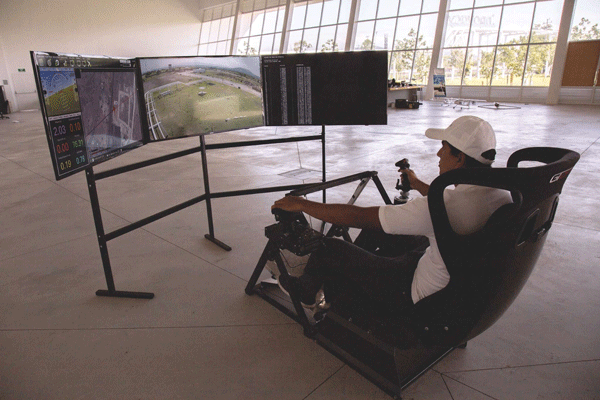
The computerized flight plan also includes takeoff and landing instructions and is programmed so the plane will land within reach of a mobile receiving station, usually a truck that is equipped with a YagiUda directional radio frequency antenna with a tracking device that can pinpoint the plane’s location and direct the antenna toward it. The receiving station also houses a ground-based virtual cockpit (Figure 3) that enables a pilot to monitor the plane and manually control it if necessary. In a configuration that resembles a gaming station, the pilot sits in a chair equipped with flight controls and monitors the plane’s flight on three large computer monitors that display the artificial horizon and the plane’s altitude, speed, and remaining battery power. Receiving stations may be positioned at the start and finish of the plane’s flight path. Since the aircraft’s maximum travel distance is ~100 km, receiving stations for longer pipelines are situated every 100 km between the beginning and end of the flight.
Depending on the country and details of the mission, personnel have to meet governmental guidelines before they can pilot a UAV for commercial applications. Piloting regulations vary from country to country, Cantó says, but most require UAV pilot training and some require a permit or certificate. To pilot a UAV in Mexico, he notes, training courses must be taken and then a permit must be acquired from the Directorate General of Civil Aviation of Mexico. Some form of insurance is always required as well.
Other regulations that pertain to operating a UAV focus on the size, weight, and flight altitude of the aircraft; areas where flying is prohibited, such as populated areas, airports, and other no-fly zones; and the time of day. One regulatory challenge Cantó mentions is the line-of-sight rule, which usually specifies that unmanned aircraft must remain within the visual line-of-sight and be close enough to the remote pilot that the aircraft can be seen unaided by any device except for corrective lenses. He comments that it would be difficult to use UAVs to inspect 100 km in remote areas if the governing line-of-sight rules are too stringent. “This is the main thing the corrosion community needs to address. We need to make sure regulations are adequate, in place, and keeping people’s safety in mind, but not so strict that the technology becomes unusable. That is the big challenge,” Cantó says.
Aside from the regulatory restrictions, Cantó sees the value of UAV technology being limited only by imagination in terms of what types of technology can be mounted on the aircraft and the tasks it can perform. “Everyone uses a quadcopter with a camera. It gets interesting when you master the flying and a particular business application,” he says.